| ☰ Menu | Exceptional airborne image of CAPER-2 |
The CAPER-2 rocket
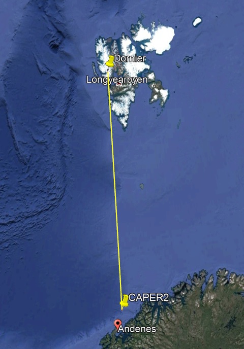
The Cusp Alfven and Plasma Electrodynamics Rocket-2 (CAPER-2) was launched from Andøya Space Center (ASC) over Svalbard into perfect optical cusp conditions as seen from KHO on 4th January 2019. The rocket was launched from Andøya at 09:27:00 UT with a flight time of only 8 minutes and 49 seconds to apogee at 774.2 km altitude above Svalbard (09:35:49 UT). Total flight time was 957 seconds or splash down at 09:42:57 UT.
The Dornier flight from Ny-Ålesund to Longyearbyen
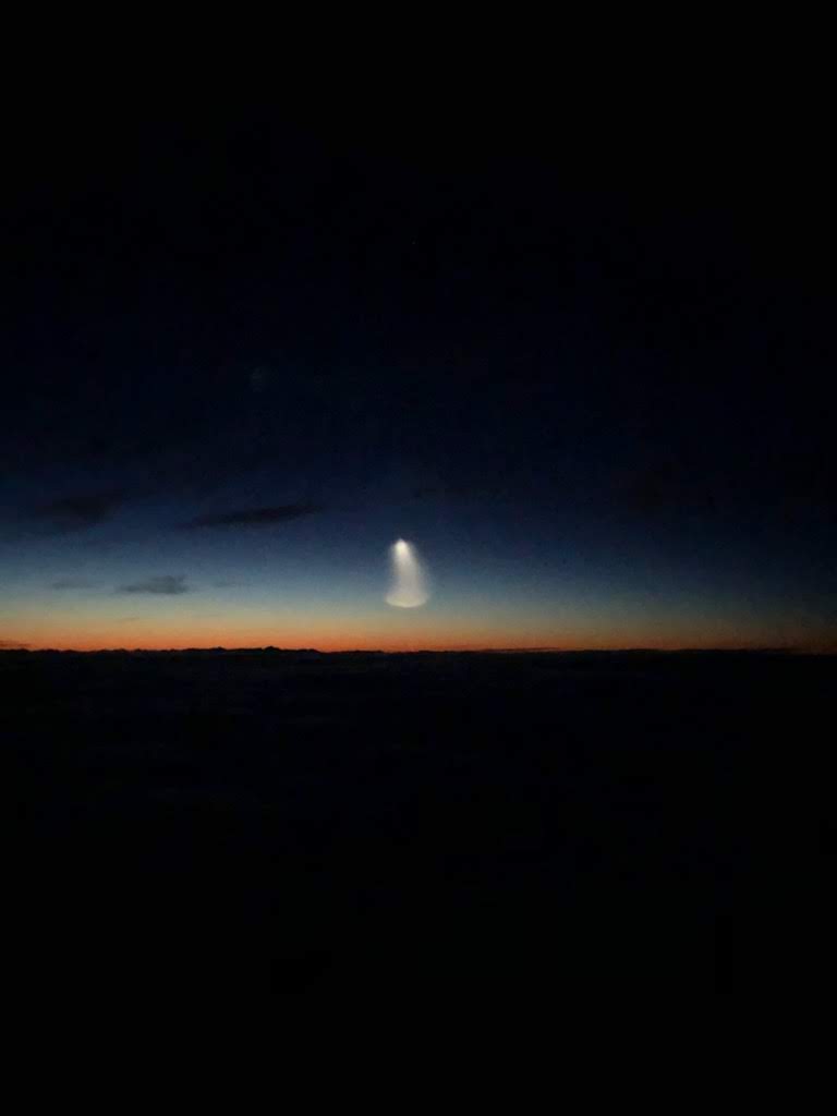
The event was captured by pilot Eivind Trondsen on the Lufttransport Dornier 228 flight from Ny-Ålesund to Longyearbyen. The sun illuminated rocket trail is seen towards the south horizon as the rocket penetrates the upper layers of the atmosphere.
Time and location
The image was captured at 09:29.04 UT which is 124 seconds into the launch of the rocket. The Dornier was then located at (78.643050N, 13.500455E) just North East of St. Jonsfjorden heading towards Longyearbyen. The flight altitude was 7000 feet. The rocket was at this point located at (70.317552N, 16.261789E) reaching an altitude of 178.823954 km. As seen from the Dornier the azimuth to the rocket is 173.5861(SE) and the elevation is 6.3858 deg. The line of sight distance to the rocket then becomes 961.269 km.
Camera details
The camera is the iPhone 8 back camera. The ISO settings were 2000 with a shutter speed of 1/4 seconds at aperture F/1.8. The focal length is just 3.99 mm. The CMOS image sensor is the Sony Exmor RS IMX315 with 4032x3024 pixels (12.2MP). The pixels are square sized 1.22 um.
Pinhole size estimates
Figure 3 shows an estimate of the rocket trail size using the camera pinhole model.
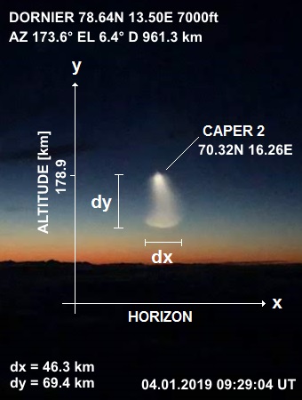
The rocket trail extends 46 km horizontally and up to 69 km vertically. The calculation assumes that the image is a full illumination exposure of the CMOS sensor.
Remark
The trail is most likely the Sun illuminated after burn of the 4th stage of the rocket motor.
At the time of the exposure the rocket moved at supersonic speed, ruling out the possibility that the
lower plume is shock related like a fighter plane reaching Mach 1 moving through water saturated air.
In addition, there is not much water vapor at these high altitudes.
Another explanation is that when the rocket passes through the upper mesosphere (~90 km) where the
atmospheric composition goes from molecular to atomic and the mean free path increases
several orders of magnitudes from cm to km, the rocket exhaust smoke is allowed to spread out freely.
This exceptional image teaches us that we should be able to track rockets early on
by optical means as long as we operate aircrafts or drones above the cloud layer.
Especially, rockets launced into the cusp from Andøya should have plumes illuminated by the Sun as seen from Svalbard.