A short background - motivation
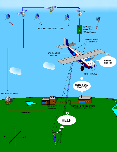
In a rescue operation it is important to be able to locate and evaluate the status Q of the person(s) that needs help. This information needs to be analyzed before any rescue team is launched. In remote areas such as in the arctic, the only means of communicating is by the iridium phone.The information can be obtained quickly by searching the area by a plane that is capable of sending position and target images to the search and rescue team. The main concept is illustrated to the right by the use of the GPS and the Iridium network. It basically involves connecting a laptop with a GPS and a digital camera to the internet. The internet connection is provided by the iridium phone.
The clue is to make user-friendly software. The procedure is done in 3 steps.
1) Acquire image and GPS position.
2) Process information:
a) Overlay position onto image.
b) Reduce size and compress image.
3) Send image by E-mail, FTP or SCP.
This page present a suite of software programs, an instrumental description, the experimental setup, and sampled data.
The online gallery shows the lates images taken by the system onboard the Dornier aircraft operated by the company Lufttransport AS in Longyearbyen, Norway.